Galleon 2026Download our mobile shopping application for faster and easy transaction.
Product ID:
148647
Identifier:
B07L29QRKB
Brand:
YellowMaps
Model:
Shipping Weight:
0 lbs
Manufacturer:
USGS
Shipping Dimension:
0 x 0 x 0 inches
Price of this item is not available.
Printed on Polypropylene (plastic)
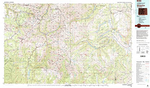
USGS topographic map of Silverton, CO, at 1:100000 scale. Heavier material. Waterproof. Tear-resistant. Foldable. Perfect for the outdoors.
Cities, towns, villages: Vanadium,Ironton,Camp Bird,Liberty Bell,Mountain Village,San Miguel,Telluride,Keystone,Ilium,Ames,Middleton,Eureka,Howardsville,Needleton,Gladstone (historical),Vance Junction,Animas Forks (historical),Cascade,Guston (historical),Alta (historical),Pandora,Silverton,Tacoma,Sneffels (historical),Lime,Ophir,Thistledown,Logtown (historical),Ophir Loop,Chattanooga (historical),Tomboy (historical),Beartown (historical)
Islands: Consult topo map preview for visible islands.
Parks and forests: Town Park,Molas Park,Telluride Historic District,Judy Long Memorial Park,Telluride Community Pool,Francis Warner Field,Bear Creek Field,Silverton Historic District
Buy products not available in the Philippines.