
We specialize in hard to find items

All Categories


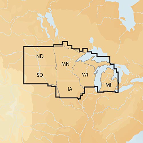


Navionics Plus Regions North Lake Charts on SD/MSD,Black
Share Tweet
*Price and Stocks may change without prior notice
*Packaging of actual item may differ from photo shown
- Electrical items MAY be 110 volts.
- 7 Day Return Policy
- All products are genuine and original
- Cash On Delivery/Cash Upon Pickup Available


Navionics Plus Regions North Lake Charts on Features
-
Max detailed charts for cruising, fishing and sailing.
-
Get more than 7,400 lakes in IA, MI, MN, ND, SD, and WI, plus all of Lake of the Woods, Rainy Lake and US waters of the regions Great Lakes.
-
Includes Nautical Chart, a robust chart resource trusted by boaters worldwide.
-
Includes SonarChartTM 1 foot HD bathymetry map that reflects ever changing conditions, and Community Edits, valuable local information added by millions of Navionics Boating app users.
-
Get the most current charts every day with daily updates for one year.
About Navionics Plus Regions North Lake Charts On
View detailed shorelines with marinas, docks and boat ramp locations. Increase your awareness of shallow waters and hazardous areas at any depth level including shoals, rocks, wrecks and more. Consult tides and currents. Fish smarter with up to 1 foot HD contours. You will find the best fishing spots with roadbeds, foundations, bridges, brush piles, culverts and creek channels. Enhance your favorite areas. SonarChartTM becomes more precise every day with sonar logs contributed by the Navionics Community from all major plotter/sonar brands and mobile devices. And with SonarChartTM Live, you can create real time personal 1 foot HD bathymetry maps on your plotter or mobile and upload sonar logs to Navionics. Navionics charts are updated with around 2,000 edits per day. You will have the latest Nautical Chart, SonarChartTM and Community Edits enriched with information from official sources, our own surveys and research, and contributions from fellow boaters. Additional features including Plotter Sync, Dock to dock Autorouting, SonarChart Live display on plotter and Advanced Map Options are available with select Raymarine models. Nautical Chart and SonarChart are preloaded and ready to use. Download daily chart updates and Community Edits for one year.


