We specialize in hard to find items

All Categories


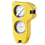
SUUNTO Tandem 360PC/360R G Compass/Clinometer: 2-in-1 Precision Compass and Clinometer for Professionals,white
Share Tweet
*Price and Stocks may change without prior notice
*Packaging of actual item may differ from photo shown
- Electrical items MAY be 110 volts.
- 7 Day Return Policy
- All products are genuine and original


SUUNTO Tandem 360PC/360R G Features
-
Professional Clinometer and Compass: SUUNTO Tandem is a liquid filled precision compass and clinometer in one compact and sturdy alloy housing; Can be mounted on tripod for stable operation; Scales for inclination in degrees and %
-
Two In One: Used all over the world by antenna installation technicians, surveyors, engineers, miners, architects and many others to measure bearings quickly, reliably and easily
-
Stay On Course: Made in Finland, Suunto mechanical compasses and clinometers help you safely and accurately navigate the great outdoors with our carefully engineered tools for challenging conditions
-
Pioneering Exploration: Combining advanced engineering and thoughtful design with ultra durable materials, our adventure ready compasses are fast, stable, and simple to use; No batteries required
-
Authentic Heritage: Founded in 1936, Suunto brings over 80 years of high quality heritage craftsmanship, relentless accuracy, and pioneering innovation to our watches, compasses, and dive products
About SUUNTO Tandem 360PC/360R G
Amazon.com The Suunto Tandem is a liquid-filled precision compass and clinometer that's an invaluable tool for surveyors, engineers, cartographers, geologists, miners, and anyone else who needs to measure directional indications, heights, vertical angles, and slopes with speed and accuracy. The dual-purpose unit--which comes in a water- and impact-resistant aluminum housing--includes scales in both degrees (0 +/- 90 degrees) and percent (0 +/- 150 percent), along with a conversion table (cosines 0 to 45 degrees) and an optical adjustment for reading. The device is particularly handy for surveying and construction projects, as it overcomes obstacles or depressions in the line of vision. And users who need to establish GPS communication or install and position a satellite antenna will love the Tandem, as it helps in establishing the right direction and correct angle and helps ensure that nothing is blocking the satellite signal. Additional features include a high degree of accuracy (the Tandem delivers precise readings in seconds), 90-degree edges for contact measuring, a lanyard, and a convenient carrying pouch with a belt loop. It's also simple to change the Tandem from compass to clinometer--all it takes is a click of the wrist. Product Description The Suunto Tandem is a precision compass and clinometer housed together in one lightweight durable package. It is widely used for anyone who needs to be able to measure directional indications, heights, vertical angles and slopes all with great speed and accuracy. The Tandem is used a lot in surveying and constructing in quarries and tunnels, especially when there are obstacles or depressions in the line of vision. It also assists in GPS communication and installations and positioning of satellite antennas. It comes standard with a lanyard, a pouch with a belt loop and it changes from compass to clinometer with a click. The Suunto tandem comes in two versions. One version comes with optical adjustment for reading and the other does not. Please choose the one the best suites your needs. The Suunto Tandem is a liquid-filled precision compass and clinometer in one compact aluminum housing. This instrument is an excellent tool for surveyors, engineers, cartographers, geologists, miners, architects and for anyone who needs to be able to measure directional indications, heights, vertical angles and slopes with speed and accuracy.