We specialize in hard to find items

All Categories


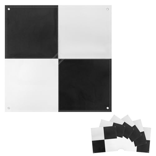


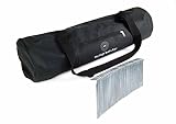
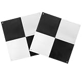
Drone Survey Ground Control Point GCP, UAV Marker for Mapping & Surveying, GCP Survey with Center Pass Through, Visible from 400 Feet, Compatible with Most Surveying Equipment Software, 6 pcs, 24 X 24
Share Tweet
of brand new stock?
or
Need this item ASAP?
Check if this is available on Amazon
or available in other sites
Send us the link so we can buy for you


Drone Survey Ground Control Point GCP, UAV Marker Features
-
High-quality Aerial Survey Target: This drone control point GCP is not only a precise aerial calibration mark, but also a high-contrast ground reference point. The center opening design makes it easy to directly insert the column to locate the coordinate measurement, or aim the drone camera at the center channel to quickly capture accurate data. This UAV GCP improves the accuracy of data collection and optimizes the efficiency of drone operations.
-
Hole Design GCP: The center hole designed on this UAV GCP makes it easy to quickly identify the center of the GCP through the surveying equipment rod to avoid tearing the aerial target. Each corner has holes for easy fixing. The anchor point design supports long-term deployment. When repeated flights are required, it can be left on site without repositioning, ensuring that the GCP provides high-precision and repeatable position data, which is suitable for precise surveying, photogrammetry.
-
Efficient Surveying GCP: The UAV GCP adopts a black white color scheme to provide optimal visibility. The color scheme enhances target exposure, ensuring clearer images and more accurate data capture. Even in complex lighting conditions, high-quality data can be reliably obtained using this GCP. Its standard black white checkerboard pattern is compatible with most photogrammetry software and software with automatic recognition function, further improving survey efficiency and accuracy.
-
Affordable Ground Control Point: This 24”x24” ariel survey targets is designed for low to mid-altitude UAV mapping and scanning, suitable for flight altitudes up to 400 feet. Compared with homemade UAV GCPs, our design has advantages in performance and economy. Standard size facilitates map scaling and verification, and provides accurate reference distances for post-processing. We ensure a more efficient and cost-effective GCP aerial survey target solution.
-
Premium Fabric for Durable GCP: This survey Mapping Target is made of 600D Oxford cloth, which is wear-resistant and waterproof; the back PE coating fading resistance, aging resistance and tear resistance. The matte finish design effectively reduces sunlight glare and overexposure, facilitating accurate selection of the target center during post-processing. It is lightweight and clearly visible, suitable for travel and field setting of UAV ground control marker.