We specialize in hard to find items

All Categories


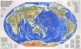
National Geographic: Earths Fractured Surface - World Tectonic Plates Wall Map - Pacific Centered - 36.25 x 22.25 inches - Art Quality Print
Share Tweet
*Price and Stocks may change without prior notice
*Packaging of actual item may differ from photo shown
- Electrical items MAY be 110 volts.
- 7 Day Return Policy
- All products are genuine and original
- Cash On Delivery/Cash Upon Pickup Available


National Geographic: Earths Fractured Surface Features
-
BUILD GLOBAL AWARENESS: Perfect for the classroom! This map identifies the tectonic plates and other geological features. A great tool to use with your students to enhance awareness of the power of the earth.
-
UNIQUE NATIONAL GEOGRAPHIC PRODUCT: This map offers a unique view of the forces of nature that are continuously shaping our world.
-
QUALITY PRINT: Printed on Polypropylene for rich clear colour and legibility. Makes for a beautiful product on your home, school or office wall.
-
DURABLE MATERIAL: This quality print material won't easily crease or tear in shipping or with use
-
ICONIC CARTOGRAPHY: National Geographic's maps are the standard others are measured against. You can count on this product having the highest quality content and display in the industry.
About National Geographic: Earths Fractured Surface
Like the pieces of a jig-saw puzzle, slabs of rocky crust - tectonic plates - fit together to form the earth's outer shell. Unlike a puzzle, the pieces of our planet are not stationary. They shift, slide and grind over each other, gradually reshaping the very ground we walk on over millions of years. This map, using National Geographic's signature colour palette, uses a Pacific-centered orientation to highlight the size and impact of the Pacific plate. Grinding against both North America's western seaboard and the eastern edges of Asia, this gigantic tectonic plate is responsible for the significant earthquake and volcanic activities experienced in places like California, Japan and Indonesia. Identify elements such as subduction zones, spreading centers, and locations of hotspots, volcanoes and earthquakes. Consider the implications of tectonic activity with a list of the most notable earthquakes and volcanoes from the 20th century. This map is a reminder of the untameable forces of our planet. National Geographic's maps are the standard by which all other reference maps are measured. The maps are meticulously researched and adhere to National Geographic's convention of making independent, apolitical decisions based on extensive research using multiple authoritative sources. Printed on polypropylene, an ideal material for wall maps as the printing brings out rich colours, and crisp edges for readability. The material is stronger than most papers and unlikely to crease or rip. The matte finish eliminates glare, and adds texture to the map. Ideal for display. Your map is rolled and packaged in a sturdy tube to protect it during shipment.