We specialize in hard to find items

 (4)
(4)


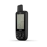
Garmin GPSMAP 67i Rugged GPS Handheld with inReach® Satellite Technology, Two-Way Messaging, Interactive SOS, Mapping
Share Tweet
*Price and Stocks may change without prior notice
*Packaging of actual item may differ from photo shown
- Electrical items MAY be 110 volts.
- 7 Day Return Policy
- All products are genuine and original


Garmin GPSMAP 67i Rugged GPS Handheld with Features
-
Large 3” sunlight-readable color display for easy viewing
-
Enable two-way messaging and location tracking via the 100% global Iridium satellite network, and trigger an interactive SOS to Garmin Response℠, a 24/7 staffed emergency response coordination center (active subscription required; some jurisdictions regulate or prohibit the use of satellite communications devices)
-
Access preloaded TopoActive mapping from Garmin, view satellite imagery, and navigate with multi-band GNSS support and sensors
-
When paired with your compatible smartphone, you can access active weather forecasts and Geocaching Live
-
Use with the Garmin Explore website or app on your compatible smartphone to help you plan trips and more
-
Get access to a wide variety of premium mapping content delivered directly to your device via Wi-Fi technology with an Outdoor Maps+ subscription
-
Internal, rechargeable lithium battery provides up to 165 hours in 10-minute tracking mode and up to 425 hours in expedition mode with 30-minute tracking intervals
About Garmin GPSMAP 67i Rugged GPS Handheld With
Go explore the outdoors — and stay connected to home — with the GPSMAP® 67i handheld. Using inReach® technology, this button-operated GPS handheld and satellite communicator enables two-way messaging and location tracking (active subscription required; some jurisdictions regulate or prohibit the use of satellite communications devices). You can also trigger an interactive SOS to Garmin Response℠, a 24/7 staffed emergency response coordination center. Navigate confidently with preloaded TopoActive mapping and satellite imagery. When paired with your compatible smartphone, you can access active weather forecasts and Geocaching Live. Use the Garmin Explore™ website or app on your compatible smartphone to help you plan trips and more, and download premium maps with an Outdoor Maps+ subscription. During extended activities, turn on expedition mode for up to 425 hours of battery life in 30-minute tracking mode.