We specialize in hard to find items

 (1)
(1)

*Price and Stocks may change without prior notice
*Packaging of actual item may differ from photo shown
- Electrical items MAY be 110 volts.
- 7 Day Return Policy
- All products are genuine and original
- Cash On Delivery/Cash Upon Pickup Available


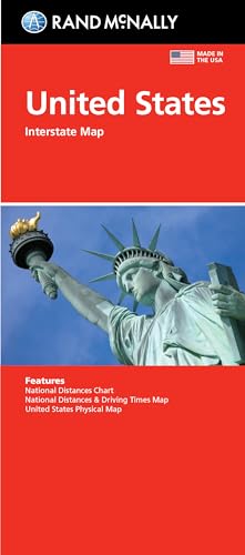
Rand McNally Folded Map: United States Map Features
-
Interstate and U.S. highways
-
Indications of cities, points of interest, airports, boundaries, and more
-
Mileage chart
-
Mileage & driving times map
-
National facts and symbols
-
Toll roads chart
-
United States physical map
-
Visitor information
-
Copyright 2021
About Rand McNally Folded Map: United States Map
Rand McNally's United States folded map features clear, easy-to-read cartography showing all Interstate and U.S. highways, along with clearly indicated cities, points of interest, airports, boundaries, and more. Rand McNally folded maps have been the trusted standard for years, offering unbeatable accuracy and reliability at a great price. •Interstate and U.S. highways. •Indications of cities, points of interest, airports, boundaries, and more. •Mileage chart. •Mileage & driving times map. •National facts and symbols. •Toll roads chart. •United States physical map. •Visitor information. Product Details: Measures 4.125" x 9" and folds out to "28”x40”.

![ibloom "Slow Rising [Squishy Collection] Milk Toast](https://images-na.ssl-images-amazon.com/images/I/4111R1QqxzL._SL160_.jpg)