We specialize in hard to find items

 (1)
(1)


*Price and Stocks may change without prior notice
*Packaging of actual item may differ from photo shown
- Electrical items MAY be 110 volts.
- 7 Day Return Policy
- All products are genuine and original
- Cash On Delivery/Cash Upon Pickup Available


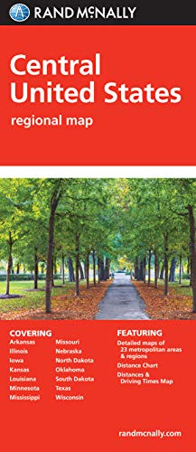
Folded Map: Central United States Features
-
Used Book in Good Condition
About Folded Map: Central United States
Rand McNally's folded map featuring the Central United States is a must-have for anyone traveling in and around this part of the country, offering unbeatable accuracy and reliability at a great price. Our trusted cartography shows all Interstate, state, and county highways, along with clearly indicated points of interest, airports, county boundaries, and more. You'll see why Rand McNally folded maps have been the trusted standard for years. Regularly updated, full-color maps Clearly labeled Interstate, U.S., state, and county highways Detail maps of major cities, a mileage chart, and a Mileages & Driving Times Map Indications of parks, points of interest, airports, county boundaries, and more Easy-to-use legend Detailed index Convenient folded size Coverage Area States covered: Arkansas, Illinois, Iowa, Kansas, Louisiana, Minnesota, Mississippi, Missouri, Nebraska, North Dakota, Oklahoma, South Dakota, Texas, and Wisconsin Product Details Measures 9.5" x 4.125" and folds out to 40" x 28".