We specialize in hard to find items

All Categories


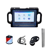
PQWT-TC500 Ground Water Detector 500M Depth Deep Water Detector For Well Drilling Kit
Share Tweet


PQWT-TC500 Ground Water Detector 500M Depth Deep Features
-
【Professional Water Detector】PQWT-TC500 is made by one of the most famous manufacturer, a professional instrument for Underground water search. Mostly used by well driller, drilling company, geologist. The maximum depth is 500m.
-
【Operational Principle】It's use the natural electric field as electromagnetic field work source, based on the resistivity differences of underground rock, mineral or groundwater, measure the natural electric field in the soil of N different components of electric frequency field .
-
【Detection Result】The instrument can automatic draw curve and profile map with one key after collect data, from the map can show water depth and lcoation.
-
【Language】 Our water detector has 6 languages (English, Frensh, Spanish, Arabic, Russian and Polish ) for options, you can learn the operations in 15 minutes by the instructions or operation video.
-
【2 Years Warranty】We guarantee quality and service. 5-7 working days fast delivery. Any quesitons please feel free to contact us, we'll have expert one-on-one guidance. Please check all the instruction in the USB disk after received device.
About PQWT-TC500 Ground Water Detector 500M Depth Deep
PQWT-TC use the natural electric field as electromagnetic field work source, based on the resistivity differences of underground rock, mineral or groundwater, measure the natural electric field in the soil of N different components of electric frequency field . After data collection by the unique built-in computing functions, the instrument can automatically draw curve chart and profile map with just one button, according to the profile map, we can clearly understand the geological structure and quickly determine the Location of ore (Sewing), hollow (cave), water (aquifer), etc.